From pv magazine Global
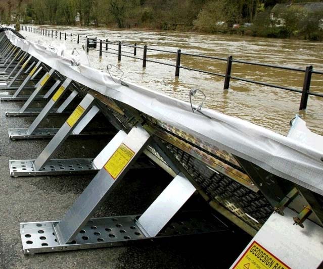
A group of researchers in Turkey has developed a new model to include flood and erosion risk to PV project siting.
The scientists claim that fixed-distance buffer zones are not sufficient to protect solar farms from flood and erosion hazards, stressing that determining a certain distance from dams currently still lacks a scientific basis.
“When we initially delved into articles related to the optimal site selection of PV plants, we couldn’t help but wonder why floods were either ignored or only briefly mentioned in most of them,” Kutay Yılmaz, corresponding author, told pv magazine. “Some previous studies suggested buffer zones ranging from 100 m to 1, 000 m to mitigate reservoir-related damages, but this approach seemed somewhat imprecise to us. Given the increasing occurrence of hydrological extremes in recent years, we felt it was necessary to adopt a more rigorous approach,” said Yilmaz.
In their study “Exploring flood and erosion risk indices for optimal solar PV site selection and assessing the influence of topographic resolution,” published in Renewable Energy, they provide a method for quantitatively assessing potential flood hazards near planned solar farms and establish six levels of flood hazards based on flow depths and flood velocities with three of the highest classes being structurally unsafe for solar PV.
For their modeling, the academics utilized the analytic hierarchy process (AHP), which is a decision-making technique based on hierarchical decomposition for organizing and prioritizing decision criteria. “AHP facilitates the resolution of complex issues that involve inputs that cannot be compared with one another, typically due to the use of different measurement units,” they explained. “Through the use of AHP, a solution model that employs homogeneous factors is developed from the original problem.”
As for erosion risk, the scientists utilized the Revised Universal Soil Loss Equation (RUSLE) approach, which considers factors such as rainfall-erosivity, soil sensitivity to erosion, and topographic features. “Erosion is a natural hazard that poses a significant risk to the structural integrity of various installations, including PV systems,” the paper notes. “To translate the erosion results into actionable insights for site selection, the severity of erosion is categorized into different classes.”
The scientists also used digital elevation models (DEMs), which are digital cartographic datasets representing a continuous topographic elevation surface to determine the distance to roads, transmission lines, and other factors. They also utilized the DEMs to analyze the influence of topographic resolution on flood and erosion hazards, and found that a lower resolution (34-meter) may provide as good results as a higher resolution (25-meter) for PV project site selection.
“It is noteworthy that the calculation process involved in determining the distance to roads, transmission lines, and other factors requires the use of DEMs,” they explained. “The study demonstrates that low-resolution topographic data can be used for site selection, provided that the data is resampled to the resolution of land use data.”
“Those results are intriguing, as even though the weights of flood and erosion in the AHP were relatively low, their impact on site selection was substantial,” said Kutay. “As we move forward, we will also consider other global-warming related criteria like sea level rise and flash precipitation, tailoring our approach to the specific characteristics and needs of each location.”
This content is protected by copyright and may not be reused. If you want to cooperate with us and would like to reuse some of our content, please contact: editors@pv-magazine.com.


By submitting this form you agree to pv magazine using your data for the purposes of publishing your comment.
Your personal data will only be disclosed or otherwise transmitted to third parties for the purposes of spam filtering or if this is necessary for technical maintenance of the website. Any other transfer to third parties will not take place unless this is justified on the basis of applicable data protection regulations or if pv magazine is legally obliged to do so.
You may revoke this consent at any time with effect for the future, in which case your personal data will be deleted immediately. Otherwise, your data will be deleted if pv magazine has processed your request or the purpose of data storage is fulfilled.
Further information on data privacy can be found in our Data Protection Policy.