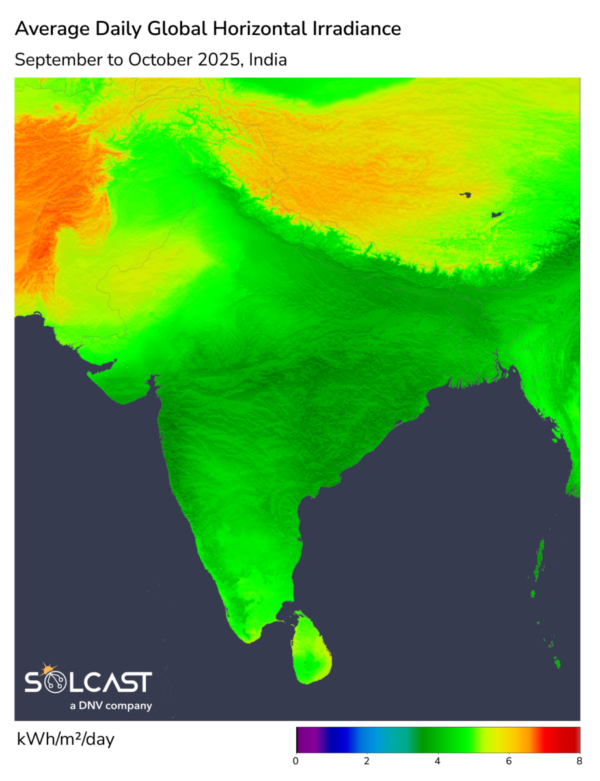
India’s solar generation potential was significantly hampered during September and October due to an intensified southwest monsoon, resulting in a 15% decrease in irradiance compared to the long-term average, according to analysis using the Solcast API. The effects were not uniform across the country, with some regions experiencing notable declines in generation while others, particularly in the Northeast, benefited from drier-than-normal conditions. The start of November has brought a cold shift, with mixed expectations for the remainder of the year as conflicting climate signals complicated forecasting.
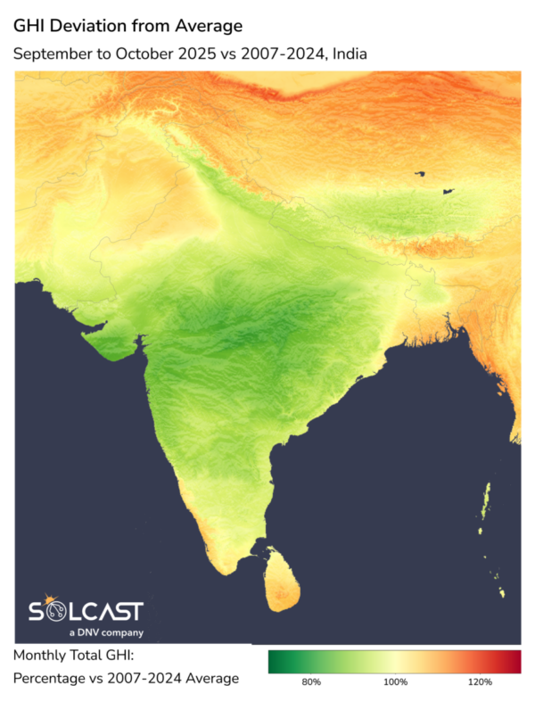
The southwest monsoon fully withdrew by October 16, having delivered 934.8 mm of rainfall across India – 8% above the seasonal norm and the highest since 2020. Central India saw the biggest increase, registering nearly 20% more rainfall than usual, driven by the frequent development of low-pressure systems in the Bay of Bengal. Conversely, North Eastern India experienced 20% below-average rainfall due to persistent high pressure that limited cloud formation and rainfall. Late in the season, Cyclone Montha brought additional rain to Andhra Pradesh and surrounding areas, further disrupting irradiance. This intensified monsoonal activity had a tangible impact on regional solar performance. In the northwest and central regions, increased cloud cover and rainfall suppressed irradiance, reducing cumulative generation.
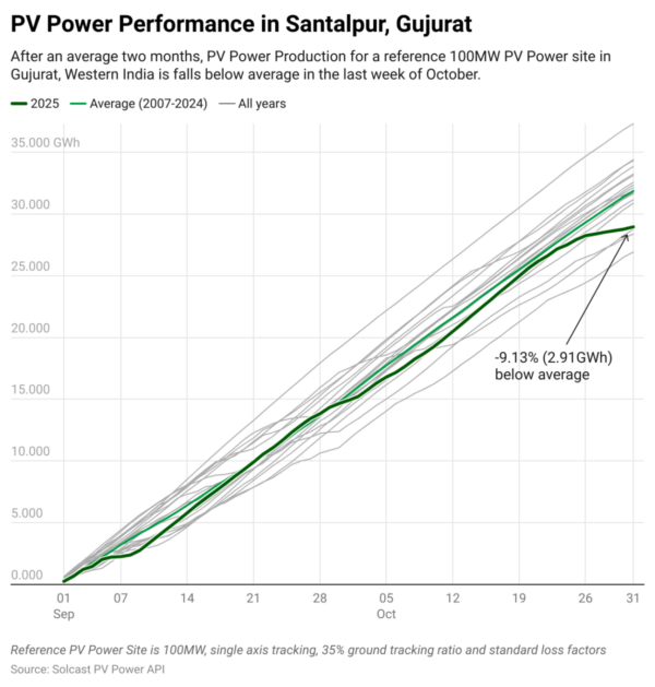
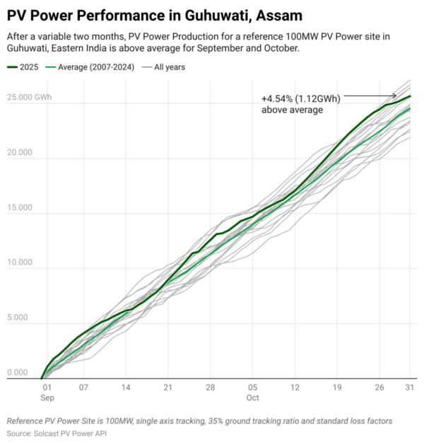
Modelling for a representative 100MW solar site at Badod in Madhya Pradesh recorded a 19.1% drop in cumulative generation across September and October compared to the 2007-2024 average. In Gujurat, Santalpur saw a 9.13% decline, 2.91 GWh, essentially all in the last week of October. In contrast, Guwahati in Assam experienced a 4.54% increase in cumulative generation, benefiting from clear skies associated with the drier-than-normal conditions.
As November commenced, temperatures fell sharply, with readings up to 3 C below average across many regions, and forecasts indicating potential drops of up to 5 C below normal in parts of the north. The onset of the Northeastern Monsoon, which typically brings about 20% of India’s annual rainfall mainly to the southeast, adds complexity to the seasonal outlook. While a negative Indian Ocean Dipole points to a weaker monsoon and potentially drier conditions, dynamical seasonal forecast models counter with expectations of above-average rainfall and continued lower-than-average irradiance into December. This divergence highlights the uncertainty in upcoming weather impacts on solar generation, with actual outcomes likely influenced by evolving atmospheric patterns.
Solcast produces these figures by tracking clouds and aerosols at 1-2km resolution globally, using satellite data and proprietary AI/ML algorithms. This data is used to drive irradiance models, enabling Solcast to calculate irradiance at high resolution, with typical bias of less than 2%, and also cloud-tracking forecasts. This data is used by more than 350 companies managing over 300 GW of solar assets globally.
The views and opinions expressed in this article are the author’s own, and do not necessarily reflect those held by pv magazine.
This content is protected by copyright and may not be reused. If you want to cooperate with us and would like to reuse some of our content, please contact: editors@pv-magazine.com.


By submitting this form you agree to pv magazine using your data for the purposes of publishing your comment.
Your personal data will only be disclosed or otherwise transmitted to third parties for the purposes of spam filtering or if this is necessary for technical maintenance of the website. Any other transfer to third parties will not take place unless this is justified on the basis of applicable data protection regulations or if pv magazine is legally obliged to do so.
You may revoke this consent at any time with effect for the future, in which case your personal data will be deleted immediately. Otherwise, your data will be deleted if pv magazine has processed your request or the purpose of data storage is fulfilled.
Further information on data privacy can be found in our Data Protection Policy.